Heat, Smoke and Finally Relief

Well, tell us how your trip went. We all want to hear about your special experience.

Moderators: teapot57, Tara

MarxMN
2.1 Donator
2.1 Donator
Posts: 597
Joined: Wed Aug 30, 2006 9:38 pm
Gender?: Male
Please add the numbers(11): 11
Location: Mazeppa, MN
Has thanked: 22 times
Been thanked: 37 times

Heat, Smoke and Finally Relief

Post by MarxMN »

Our 2023 Glacier hiking trip was August 12 -20. We arrived to hot temperatures with highs in the mid-90s the first several days. We also had smoky skies and smoky air a couple days. Then a cold front moved through with a little rain and cooler air – a great relief. Temperatures in the 90s are not great for hiking, temperatures in the 70 s are much better.

August 12-13 Arrival
We flew into Great Falls arriving late in the evening of August 12. The next morning we met another of our group at the motel, stopped at Smith’s for groceries and then headed to Glacier. Our goal was the West Glacier KOA. We stopped in Browning to fill the gas tank, in East Glacier to see the Glacier Park Lodge and then on to West Glacier.

The “Big Tree” Lodge – Glacier Park Lodge
A-1 Glacier Park Lodge.JPG
A-1 Glacier Park Lodge.JPG (224.08 KiB) Viewed 625 times


Inside Glacier Park Lodge
A-2 Glacier Park Lodge.JPG
A-2 Glacier Park Lodge.JPG (151.38 KiB) Viewed 625 times


“See America First” emblem in an exhibit in the Glacier Park Lodge lobby
A-4 See America First (GPL).JPG
A-4 See America First (GPL).JPG (237.48 KiB) Viewed 625 times


We had dinner at Eddie’s in Apgar.
Last edited by MarxMN on Wed Feb 21, 2024 9:46 am, edited 2 times in total.
MarxMN
2.1 Donator
2.1 Donator
Posts: 597
Joined: Wed Aug 30, 2006 9:38 pm
Gender?: Male
Please add the numbers(11): 11
Location: Mazeppa, MN
Has thanked: 22 times
Been thanked: 37 times

Re: Heat, Smoke and Finally Relief

Post by MarxMN »

August 14 - Apgar Lookout

Mike and I hiked to Apgar Lookout while the rest of the group took a Red Bus tour from lake McDonald Lodge. I had not been on the Apgar Lookout trail since 2009. Portions of this area burned in the Robert Fire of 2003.

Looking back down the Apgar Lookout Trail
B-1 Apgar Lookout Trail.JPG
B-1 Apgar Lookout Trail.JPG (291.72 KiB) Viewed 592 times

Oregon Grape
B-3 Oregon Grape.JPG
B-3 Oregon Grape.JPG (331.08 KiB) Viewed 592 times

Snowberry
B-7 Snowberry.JPG
B-7 Snowberry.JPG (236.53 KiB) Viewed 592 times

Apgar Lookout from trail.
B-12 Apgar Lookout.JPG
B-12 Apgar Lookout.JPG (251 KiB) Viewed 592 times

Apgar Lookout (with people)
B-17 Apgar Lookout (Mike).JPG
B-17 Apgar Lookout (Mike).JPG (305.87 KiB) Viewed 592 times

I was surprised that we could no longer see Lake McDonald from the base or the balcony of the Lookout. I had remembered views of the lake from the lookout back in 2009. Obviously, the trees are 14 years more mature than in 2009. And when I look at the Glacier webcam picture from Apgar Lookout the trees are obvious. The webcam is mounted higher on other equipment at the lookout site so it still shows Lake McDonald.


Lake McDonald is behind the trees.
B-15 View Southeast from Lookout.JPG
B-15 View Southeast from Lookout.JPG (347.13 KiB) Viewed 592 times

The view of Lake McDonald from Apgar Lookout in 2009.
18zc Lake McDonald.JPG
18zc Lake McDonald.JPG (202.88 KiB) Viewed 592 times
We found the trail is 3.8 miles each way rather than a shorter distance stated in my trail guide which is from the 1980s. We saw about 25 people on the trail but 15 of them were from the same family (including grandma and grandpa, parents and grandkids). That group was at the lookout at the same time as we were.
Last edited by MarxMN on Wed Feb 21, 2024 9:05 am, edited 1 time in total.
MarxMN
2.1 Donator
2.1 Donator
Posts: 597
Joined: Wed Aug 30, 2006 9:38 pm
Gender?: Male
Please add the numbers(11): 11
Location: Mazeppa, MN
Has thanked: 22 times
Been thanked: 37 times

Re: Heat, Smoke and Finally Relief

Post by MarxMN »

August 14 - Part 2 - Johns Lake and McDonald Creek

After the Apgar Lookout hike we drove to Lake McDonald Lodge to meet the rest of our group. Then we hiked the John’s Lake trail and along McDonald Creek.

Lake McDonald Lodge and a Red Bus
B-23 Red Bus.JPG
B-23 Red Bus.JPG (273.43 KiB) Viewed 592 times


John’s Lake
B-27 John's Lake.JPG
B-27 John's Lake.JPG (295.77 KiB) Viewed 592 times


The Trail goes through cedars.
B-30 Cedar Forest.JPG
B-30 Cedar Forest.JPG (364.54 KiB) Viewed 592 times


McDonald Creek
B-38 McDonald Creek.JPG
B-38 McDonald Creek.JPG (288.83 KiB) Viewed 592 times


McDonald Falls
B-34 McDonald Falls.JPG
B-34 McDonald Falls.JPG (351.12 KiB) Viewed 592 times


Tunnel Under Going to the Sun Road Near Lake Near the Head of Lake McDonald
B-43 West Side GTTS Road Tunnel.JPG
B-43 West Side GTTS Road Tunnel.JPG (97.82 KiB) Viewed 592 times

The tunnel allows horses to pass under the Going to the Sun Road. There is another tunnel under Going to the Sun Road at the Jackson Glacier Overlook.

Dinner was at Packers Roost down Highway 2 from the West Glacier KOA.
teapot57
Moderator & 2.1 Donator
Posts: 945
Joined: Mon May 20, 2013 3:59 pm
Gender?: Female
Please add the numbers(11): 11
Location: Calgary, AB
Has thanked: 96 times
Been thanked: 77 times

Re: Heat, Smoke and Finally Relief

Post by teapot57 »

If I climbed up to Apgar Lookout and couldn’t see the lake, I’d be disappointed! I had no idea.

I’ve never eaten at Packer’s Roost. how’s the food?
MarxMN
2.1 Donator
2.1 Donator
Posts: 597
Joined: Wed Aug 30, 2006 9:38 pm
Gender?: Male
Please add the numbers(11): 11
Location: Mazeppa, MN
Has thanked: 22 times
Been thanked: 37 times

Re: Heat, Smoke and Finally Relief

Post by MarxMN »

teapot57 - We could see that Lake McDonald was there through the trees but certainly not the view that the NPS webcam shows. The view had changed significantly from what it was in 2009. But trees do grow taller.

The food at Packer's Roost was good - it was burgers and sandwiches.

Bill
MarxMN
2.1 Donator
2.1 Donator
Posts: 597
Joined: Wed Aug 30, 2006 9:38 pm
Gender?: Male
Please add the numbers(11): 11
Location: Mazeppa, MN
Has thanked: 22 times
Been thanked: 37 times

Re: Heat, Smoke and Finally Relief

Post by MarxMN »

August 15 – Mt. Aeneas – Jewel Basin

A friend who lives near Bigfork invited us to visit her and hike in the Jewel Basin in the Flathead National Forest. We met at her house and then drove about six miles up a Forest Service road to the Camp Misery parking area. From there we hiked the trails to Mount Aeneas. Our friend hiked here regularily but the rest of us had never been in the Jewel Basin.

Elderberry
C-5 Elderberry.JPG
C-5 Elderberry.JPG (231.87 KiB) Viewed 539 times

Fireweed
C-6 Fireweed.JPG
C-6 Fireweed.JPG (417.12 KiB) Viewed 539 times

Grouse Whortleberry
C-8 Grouse Whortleberry.JPG
C-8 Grouse Whortleberry.JPG (341.38 KiB) Viewed 539 times

Dusky Grouse
C-28 Dusky Grouse.JPG
C-28 Dusky Grouse.JPG (221.63 KiB) Viewed 539 times

Ridge leading to the top of Mt. Aeneas
C-11 Ridge Leading to Mt. Aeneas.JPG
C-11 Ridge Leading to Mt. Aeneas.JPG (278.38 KiB) Viewed 539 times

We had views of the Flathead Valley.

Flathead Valley with Flathead Lake in the center left.
C-16 Flathead Valley.JPG
C-16 Flathead Valley.JPG (158.65 KiB) Viewed 539 times
We could see several small lakes (jewels) in the Jewel Basin.


Jewels of the Jewel Basin - the nearest lake is Birch Lake
C-35a Birch Lake and other jewels.jpg
C-35a Birch Lake and other jewels.jpg (278.43 KiB) Viewed 539 times

Hungry Horse Reservoir (looking east from Mt. Aeneas)
C-37 Hungry Horse Reservoir.JPG
C-37 Hungry Horse Reservoir.JPG (188.66 KiB) Viewed 539 times

Smoke from a Fire to the South
C-40 FIre to south.JPG
C-40 FIre to south.JPG (127.81 KiB) Viewed 539 times

Where we descended from Mt. Aeneas
C-49 Mt. Aeneas.JPG
C-49 Mt. Aeneas.JPG (369.96 KiB) Viewed 539 times

We hiked down the other side of Mt. Aeneas taking the trail past the Picnic Lakes. It was another hot day and several of us spent a little time in the lake. After that it was down the trails back to our cars and then to our friend’s house for a wonderful dinner.
Last edited by MarxMN on Fri Feb 23, 2024 9:22 pm, edited 1 time in total.
User avatar
tibber
2.0 Donator
2.0 Donator
Posts: 477
Joined: Thu Jul 08, 2010 11:50 am
Gender?: Female
Please add the numbers(11): 11
Location: Phoenix, AZ
Has thanked: 79 times
Been thanked: 31 times

Re: Heat, Smoke and Finally Relief

Post by tibber »

Interesting rock color on Mt. Aeneas. Bummer about the heat. Quite the plume of smoke you saw too.
MarxMN
2.1 Donator
2.1 Donator
Posts: 597
Joined: Wed Aug 30, 2006 9:38 pm
Gender?: Male
Please add the numbers(11): 11
Location: Mazeppa, MN
Has thanked: 22 times
Been thanked: 37 times

Re: Heat, Smoke and Finally Relief

Post by MarxMN »

August 16 – Lake McDonald – North Shore Trail

We had planned to hike to Huckleberry Mountain Lookout this day but we were too worn out from hiking in the heat the previous two days to try another hike with considerable elevation change. We looked for something on the west side without a lot of elevation change. We settled on the trail on the north shore of Lake McDonald which none of us had hiked before. The trail can be accessed from the Fish Lake Campground or from the Inside North Fork Road. Lake McDonald is visible from many sections of the trail but other sections are in more wooded areas. Most of this area burned in the mid-2000s.

In addition to the heat this day the sky was very smokey and hazy. While hiking in the Jewel Basin the previouse day we saw the smoke from two fires - the one to the south that is shown in the picture from Mt. Aeneas and another fire that was on the east side of the Hungry Horse Resevoir. The smoke duiring this day's hike could have been from either or both of thoswe fires. Much of the day it filled the sky.


Lake McDonald and Smokey Sky
D-2 Lake McDonald.JPG
D-2 Lake McDonald.JPG (235.48 KiB) Viewed 507 times

Lake McDonald from the Trail
D-3 Lake McDonald from Trail.JPG
D-3 Lake McDonald from Trail.JPG (177.97 KiB) Viewed 507 times

Fireweed Seedheads
D-4 Fireweed Seeds.JPG
D-4 Fireweed Seeds.JPG (197.79 KiB) Viewed 507 times

Hollyhock
D-6 Hollyhocks.JPG
D-6 Hollyhocks.JPG (78.89 KiB) Viewed 507 times
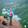
On the Trail
D-7 Mike, Julie and Claire on Trail.JPG
D-7 Mike, Julie and Claire on Trail.JPG (340.74 KiB) Viewed 507 times

Lake McDonald Campground Area - Campsites were scattered throughout this area.
D-8 Campground Area.JPG
D-8 Campground Area.JPG (320.9 KiB) Viewed 507 times

Beach Area Adjacent to the Campground
D-12 Lake McDonald & Swimmers.JPG
D-12 Lake McDonald & Swimmers.JPG (187.54 KiB) Viewed 507 times

Flute Music on the Beach (The boat is a NPS boat used by two park rangers visiting the campground.)
D-14 Nina and Flute.JPG
D-14 Nina and Flute.JPG (332 KiB) Viewed 507 times

The hike from the parking area on the Inside North Fork Road to the campground was five miles so a ten mile round trip hike. After a nice lunch break at the beach on Lake McDonald (with some of us swimming in the lake) we headed back. When we started the car at the gravel parking are the car thermometer read 94 degrees.

Dinner was at the Sunflower Café in the Glacier Campground on Highway 2 a short distance from the KOA.
orin
Posts: 469
Joined: Mon May 15, 2006 11:02 pm
Please add the numbers(11): 0
Location: Seattle
Has thanked: 37 times
Been thanked: 49 times

Re: Heat, Smoke and Finally Relief

Post by orin »

That Lake McDonald campsite doesn't look like the most desireable I've seen in Glacier especially under a hot sun. The beach would be nice though.
llholmes1948
Donator
Donator
Posts: 5224
Joined: Sun May 20, 2007 8:48 pm
Please add the numbers(11): 0
Location: Maine
Has thanked: 37 times
Been thanked: 47 times

Re: Heat, Smoke and Finally Relief

Post by llholmes1948 »

Bill,
Thanks for that great report and photos. Glad to see that you survived the heat and smoke and had a good trip.

Good to know that the view of Lake McDonald is now becoming obscured by tree growth around Apgar Lookout. I often recommend the hike to people (including my daughter this past summer but she didn't do that hike) for the great view of Lake McDonald. I guess I will have to put in a few caveats to this recommendation now.

We hiked to Apgar Lookout in 2008 and views were great but that was a long time ago. We were planning to hike there again in 2014 but the day was very hot and we opted for Snyder Lake instead which was a great alternative.

Lyman
MarxMN
2.1 Donator
2.1 Donator
Posts: 597
Joined: Wed Aug 30, 2006 9:38 pm
Gender?: Male
Please add the numbers(11): 11
Location: Mazeppa, MN
Has thanked: 22 times
Been thanked: 37 times

Re: Heat, Smoke and Finally Relief

Post by MarxMN »

Orin - the Lake McDonald Campsite had no shade. It may have been a much nicer site before the fire. The Park Service was in the process of doing some work at the site and the trail through the site had recently been paved.


Lyman - I was surprised too. On the way up I told Mike about the great view of Lake McDonald that we have based on what I remembered from 2009. But trees do grow. It is still a nice hike.

BIll
al_in_al
Posts: 297
Joined: Tue Oct 21, 2014 7:13 am
Gender?: Female
Please add the numbers(11): 11
Has thanked: 4 times
Been thanked: 109 times

Re: Heat, Smoke and Finally Relief

Post by al_in_al »

Thanks for sharing so far - looking forward to the smoke relief at the end of your trip!

I'd love to hike in the Jewel Basin this summer. What was the forest service road to Camp Misery like? From what I've read, it looks like it might be too rough for a small sedan.

I've never hiked the north shore of Lake McDonald either, and it's certainly on the list for this year as well for an easier day, maybe early in the season.
MarxMN
2.1 Donator
2.1 Donator
Posts: 597
Joined: Wed Aug 30, 2006 9:38 pm
Gender?: Male
Please add the numbers(11): 11
Location: Mazeppa, MN
Has thanked: 22 times
Been thanked: 37 times

Re: Heat, Smoke and Finally Relief

Post by MarxMN »

al_in_al

The forest service road to the Camp Misery parking area was very dusty but otherwise decent. There were mild potholes that would be mudholes if there had been recent rain. We were in a Toyota Camry and were fine.
MarxMN
2.1 Donator
2.1 Donator
Posts: 597
Joined: Wed Aug 30, 2006 9:38 pm
Gender?: Male
Please add the numbers(11): 11
Location: Mazeppa, MN
Has thanked: 22 times
Been thanked: 37 times

Re: Heat, Smoke and Finally Relief

Post by MarxMN »

August 17 – Drive to St. Mary – Our Tourist Day

This was our day to move to the East Side – from the West Glacier KOA to the St. Mary KOA. We had breakfast, packed the cars and left the West Glacier KOA. The sky was very hazy and we could smell smoke in the air. We used our Going to the Sun Road passes to enter the park at West Glacier and drove on to Logan Pass. We wanted to go to the visitor center and walk up to the Hidden Lake Overlook. The parking lot was full so we started down the east side to the first parking area where there was a parking space, left one car and all packed into the second car. Then we drove back to Logan Pass, watched for someone who looked ready to leave and claimed that parking place. However, smoke was even heavier in the air at Logan Pass so we decided not to go to the Hidden Lake Overlook. We looked around in the visitor center and gift shop and headed back to the car.

Logan Pass and Mt. Reynolds
E-2 Logan Pass & Reynolds.JPG
E-2 Logan Pass & Reynolds.JPG (191.6 KiB) Viewed 405 times

We picked up the second car and headed down the road. We did stop at the Jackson Glacier Overlook to walk through the second tunnel under the Going to the Sun Road. This tunnel allowed horses to pass under the road on the trail that goes from Reynolds Creek to Piegan Pass.

East Side Tunnel
E-5 East Side Tunnel Under GTTS Road - Jackson Glacier Overlook.JPG
E-5 East Side Tunnel Under GTTS Road - Jackson Glacier Overlook.JPG (327.03 KiB) Viewed 405 times

We stopped at the St. Mary Visitor and then to the KOA. At St. Mary the air no longer smelled like smoke and was much cooler. After dinner at Two Sisters we went to the Native America Speaks program at Chewing Blackbones Campground. The presenter was Mariah Gladstone telling us Blackfoot stories. Back at the KOA the temperature was chilly with a few sprinkles, a pleasant contrast to the previous days.
MarxMN
2.1 Donator
2.1 Donator
Posts: 597
Joined: Wed Aug 30, 2006 9:38 pm
Gender?: Male
Please add the numbers(11): 11
Location: Mazeppa, MN
Has thanked: 22 times
Been thanked: 37 times

Re: Heat, Smoke and Finally Relief

Post by MarxMN »

August 18 Grinnell Glacier (Part 1)

We drove to Many Glacier, parked in the Many Glacier Hotel lot and started the hike to Grinnell Glacier. The cooler temperature along with a breeze coming down the valley made hiking very pleasant.

Grinnell Point and Swiftcurrent Lake
F-1 Grinnell Point & Swiftcurrent lake.JPG
F-1 Grinnell Point & Swiftcurrent lake.JPG (203.45 KiB) Viewed 386 times

The Morning Eagle on Lake Josephine
F-5 Josephine Lake.JPG
F-5 Josephine Lake.JPG (228.87 KiB) Viewed 386 times

Head of Lake Josephine
F-7 Head of Josephine Lake.JPG
F-7 Head of Josephine Lake.JPG (275.6 KiB) Viewed 386 times

On the Trail
F-8 Grinnell Glacier Trail.JPG
F-8 Grinnell Glacier Trail.JPG (332.58 KiB) Viewed 386 times

Caterpillar on the Trail
F-9 Caterpillar.JPG
F-9 Caterpillar.JPG (331.72 KiB) Viewed 386 times

Another Caterpillar
F-12 Caterpillar.JPG
F-12 Caterpillar.JPG (271.42 KiB) Viewed 386 times

Yellow Monkeyflower
F-16 Yellow Monkeyflower.JPG
F-16 Yellow Monkeyflower.JPG (316.37 KiB) Viewed 386 times

Red Monkeyflower
F-17 Red Monkeyflower.JPG
F-17 Red Monkeyflower.JPG (210.76 KiB) Viewed 386 times

Grinnell Glacier Basin
F-18 Waterfall from Grinnell Glacier.JPG
F-18 Waterfall from Grinnell Glacier.JPG (250.46 KiB) Viewed 386 times
Post Reply

Return to “Trip Reports”